Travel keeps your mind engaged in the same way a 1000 piece puzzle or a difficult crossword does and having the right tools makes all the difference.
Travel, especially full-time travel, has many moving parts and keeping them all aligned and pointing in the same direction is engaging but not difficult when you have good tools at your disposal.

When we first arrived in Basel, Switzerland, stepping out from the Bahnhof Basel train station, we were confronted with a dizzying intersection of trams, buses, taxis and streets all going in every direction. To any traveler, arriving in a busy city for the first time, this cacophony of sites and sounds for a moment or two can be paralyzing.
As we stood motionless in the plaza, taking it all in, busy commuters brushed past us as they skillfully slipped down the streets and were gone. There were travelers pulling out their maps, trying to orient themselves to the train station as they puzzled over which street might take them to their destination; but not us.
After only a few seconds of reflection we were walking the 205 meters to one of eight tram stops in the plaza where we knew in 5 minutes we could catch tram number 46 on the Green Line which would transport us 12 minutes through the city and drop us a mere 36 meters from our destination. Maneuvering through a small crowd of individuals, who were shifting about the platform trying to determine if this was the correct tram or not, we edged our way onboard and settled into our seats and off we went.
To be fair, arriving in any city for the first time is bewildering and to truly enjoy a city you need the time to push through the mist, navigating farther and farther afield. More than anything else, it is this journey that makes slow travel so wonderful and having the right tools makes it easier to get to that place in time when a city (or country) stops being an unfamiliar acquaintance and becomes a more familiar friend.
Becoming Comfortably Uncomfortable
Years ago we went to Fiji for an extended vacation. We traveled all over the main island and caught a cruise to the outer islands. We attended more than one luau, ate some very interesting food, played beach volleyball with the natives and met many wonderful people from all over the world.
Upon returning a coworker mentioned that he too had been to Fiji. Excited to hear his experiences we started comparing notes and discovered that he and his wife stayed the entire three weeks of their time in Fiji at the Hilton Resort. Their airport taxi was the only time they ventured past the gates of the hotel.
Everyone has different goals when traveling but for us, that seemed like a long way to go to stay in just one place, regardless how nice the resort was. We felt that they missed so much of what makes Fiji a great destination.
The reason for his choice was that it was simply too difficult and uncomfortable to navigate the unfamiliar. Staying in the resort was easy and stress free. There are many ways to travel and if that resort was their definition of a great vacation, then they succeeded.
However, if you find yourself in similar circumstances but would prefer to explore more, then maybe these tips will be useful. Today there are some great tools that help make the uncomfortable less so, quickly enabling you to get your bearings. Instead of weeks wandering around in a fog, having the right tool can help you get anywhere and in a few short days you can zip about the city like a local.
Google Maps is one such tool.
Google Maps
Google Maps is no doubt one of the most enabling applications available today. In the last few years the dizzying amount of useful information that has been added to this application is astounding. Unfortunately, in an effort to monetize Google Maps, the map is becoming cluttered with limited ability to turn on or off features as they are needed. Even so, it remains a wonderful tool.
Finding and booking a flight or going on a car trip requires additional tools so we will leave those topics for another day. In that blog we will also share how we deal with those enigmatic directions we sometimes get; “Be certain to turn at the small green sign or you will miss the parking lot entirely.” (and have to drive another 100 km before you can turn around).
Instead, since we use public transportation more often than any other form of transportation, we want to share how we use Google Maps with taxis, ride-share services, buses, rapid transit and trains. This is all relatively straightforward but if you want to track your progress you will need a smartphone that has cellular access.

Taxi Services
When we initially arrive in any city we usually take a taxi to our lodgings. They are plentiful at airports and train stations (usually) but before we begin our trip we use Google Maps to do some planning.
Once we have the address of where we are staying we use Google Maps to determine the best route from our arrival point to our destination so we can make an educated guess as to the cost of a taxi. Google Maps will display the shortest route giving the estimated distance and with that, it is easy enough to “ballpark” the taxi fare.
Knowing approximately how much the fare should be helps us budget but it also helps us notice if the charges are a significant departure from what we expected the fare to be. If you have no idea what the taxi fare should be then it is easier to be overcharged. Keep in mind that there may be additional valid charges, for example, extra baggage handling, tolls, airport levies and fares that may be greater at night than during the day.
Knowing the approximate cost of a taxi also comes in handy when our hosts offer “Transfer Services” from the airport or train station. Knowing what a taxi might cost allows us to make an informed choice.

We use Google Maps, together with other tools, while we are searching for a place to stay. Maps can determine if our proposed lodgings are close enough to our point of arrival to make a taxi cost effective. If the distance is substantial then we might adjust our plans or look for alternatives. We think it’s good to know, before we land, if the airport is so far out of town it might as well be in the next city, as it sometimes is.
The estimated time to travel between these two points is provided in Google Maps, which is helpful when someone is waiting for us to arrive. In some cases our arrival, late or early, might result in certain fees being charged so knowing when we expect to arrive is useful. When leaving a city, if you need to arrange a taxi to your point of departure, knowing how long the taxi ride will take, lets you decide when to set your alarm.
Whether we catch the taxi at the taxi stand or hail one on the street, we frequently have the address of our destination on the screen of our phone in case our language skills are lacking. It is often easier for the taxi driver to read the address rather than trying to understand our strained pronunciation.
We also have Google Maps up and running on our smartphone so we can track our progress while in the taxi. We use this is a bit of an added security feature even though we have never had a bad experience (so far). Our experience has been that when a taxi driver becomes lost they have turned off the meter until we get back on track. Still, it might be good that the driver knows you are paying attention.
When calling for a taxi, referring to a major landmark or hotel around you is often useful, especially when you are having language challenges. Rather than trying to explain your address to them, give them a name that is more familiar, even if you have to walk a bit to meet them. This little trick has served us well.
Remember too that not all taxis accept credit cards, so make certain you have a sufficient amount of cash with you. If you aren’t certain or short on cash then maybe a ride-share service is available.

Ride-Share Services
In many cities there are alternative ride-share services. These are useful when ordering a taxi by phone becomes complicated by language differences. The advantage of a ride-share app is that you can enter your location and your destination, online, using copy and paste if necessary, getting the directions out of the way so you can chat with the driver about less important topics. Having the credit card charged automatically is also a nice feature ensuring no money has to change hands.
We have used Uber extensively in the US but here in Europe we have had more luck with Cabify. Both apps display the route saving you having to track where you are going on Google Maps or explain it to the driver. The app also provides the driver’s name and license plate number for security. I suggest you check both before you get in the car. Personal security is often raised as an issue when you employ a taxi, a ride-share service or a tuk-tuk so this extra level of assurance is welcomed.
We use taxis and ride-share services interchangeably when we can, depending on what it is that we are doing.
Purposefully getting lost in a city, while staying within your comfort level, can be a great way to experience all that a city has to offer. When it is time to return home it’s an easy matter to ask any hotel desk clerk to call you a taxi. Or use the hotel’s lobby to wait while you summon a ride-share service.
City Buses
We don’t normally take the city bus but sometimes there are few other choices. The few times we have taken a city bus in Europe we have found them to be clean and reasonably comfortable. What we mostly dislike about city buses is that we are often confused about just about everything. Seldom do we know how to pay or how much. And by just looking out the window we never know where we are or what stop we are supposed to get off at.
In Europe, there are a few solutions in place on the buses (but not all of them). Some of the ones we have taken you pay the driver who will graciously make change if you use small bills.
In Spain, fares seem to change depending on the day of the week and if there is a festival going on or not so we just plunk down what we think is more than enough money and are happy trusting the driver to deal with it. It is very rare to find a driver that isn’t helpful.
Be sure to take your ticket.
Some bus stops have monitors at the kiosk displaying the number and arrival time of the next bus and inside some buses there is a monitor mounted to the ceiling that shows the route and highlights each stop. In these cases, if you know where you want to disembark, you can usually watch the monitor and figure things out; if the monitor is working. In smaller communities you can tell the driver where you want to go and they will notify you when it’s time to disembark.
The good news is Google Maps takes riding a bus to a new level, informing you where to catch your bus, when your bus is about to arrive, displaying your progress on your smartphone, highlighting stops along the way and more. If you were ever unsure about taking a bus then worry no more.
For example, if we wanted to take the bus from Stockholm Värtahamnen to Norrmalmstorg this is what Google Maps will display with the route highlighted in blue.

Starting at the top left we learn:
The next bus nearest Stockholm Värtahamnen will leave at 11:16 AM and the total trip will take 20 minutes. The bus we want to catch is Bus 76. The bus stop is a 3 minute walk from where we are. If we doddle no worries because there is a bus every 15 minutes. Good to know.
We can add this trip to our calendar when we are planning ahead and intend to take this trip later. When planning ahead we might also want to know when the last bus will depart or when the first bus in the morning leaves. In that case we click on the SCHEDULE EXPLORER and scroll through the display, or enter our data at the top, to see our options.
We can even check to see if the bus is scheduled to run on Sunday which is a great feature when it comes to buses, although you should double-check this when special events are happening. We have learned that “scheduled to run” and “actually running” are two separate things when celebrations are involved.

The next section displays the stops along the route so you can know how many stops you will make before reaching your final destination. This section also becomes live when you start your trip highlighting each stop as you arrive so you always know exactly where you are. If that isn’t enough, your current location is tracked on the map and your phone will vibrate to alert you that you are arriving at your destination.
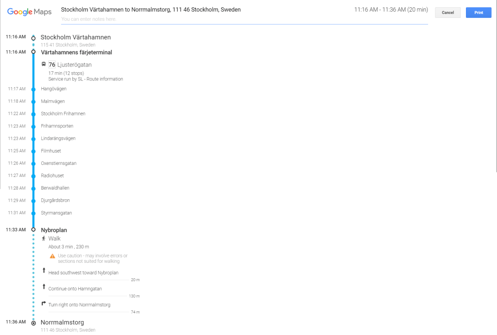
What is important to know is that this screen is time sensitive. You must have this screen up and active a minute or more before you start your trip or it may not display because the start time has passed. If that happens then you can always track your progress on the map, which won’t give you the same information but it will be more than sufficient.
Once you disembark you have instructions to walk the last 230m.
We have used city buses in France to get to wineries or other places that were a bit out of town and in Spain to get to town when we were a bit out of town. In doing so we have learned that when taking a city bus there are certain local conventions that you should be aware of. For example, in some circumstances there is an ordered sequence to board the bus, usually a “first-come first-served” arrangement. This is valid whether or not there is a queue forming when you arrive at the bus stop.
Long-distance Buses
For longer trips we might choose a Long-distance Bus, which is available on many routes not serviced by trains. Before we book a trip on a Long-distance Bus we find it very useful to understand how many hours the trip is going to be and how many stops we will have to make.
Google Maps will identify if we will be arriving at a bus station or if the bus merely stops at a specific location, often in the center of town. From there we will know if we can walk to our hotel, if we are staying overnight, or if the site we have come to see is nearby. Finally, using the SCHEDULE EXPLORER, we can plan our return trip.
Comfortable, modern and safe, we have enjoyed the bus trips we have made and tracking the trip on Google Maps helps us identify sites along the way – especially useful if we take photos.
Trains
As far as Google Maps is concerned, taking a train is no different than taking a long-distance bus, although, as we have often said, we enjoy taking the train.
What is worth mentioning, whether it is a bus trip or a train ride, is that we find it easier and more effective to plan the trip on Google Maps rather than using the sites provided by the individual companies.
Rapid Transit
Our preferred means of transit in a city is the Metro (rapid transit). Fast and safe, rapid transit is an excellent way to zip around a city.
Once again Google Maps is indispensable. When searching a city with the Transit option enabled you are introduced to the metro transit lines and stations, tram stops and railway stations of that city. This is the first step in informing you as to the many transportation options available.

When visiting a city and its museums, we will zoom in closer for a map that is more targeted but if we are looking for lodging a little outside the hubbub of Old Town and the tourist areas, yet close to a transit station, then a larger view is a great help.

When you locate a museum or gallery you want to visit, there are ways to mark those attractions on Google Maps. It is then easy to see the metro station closest and select it as a destination end-point. Or you can simply enter the address of the museum or gallery as a destination and you get all the same information we previously mentioned.
Marking the places you are interested in on Google Maps, allows you to see where clusters of sites might be close to a certain metro station. Or you might plot your travels along a string of markers to optimize your day noting the nearest metro station and selecting it to determine the best route.
Once again, when you start your search, Google assumes you are about to leave in the next few minutes but you have the option to enter the necessary information for a trip at a later time – after you have finished your coffee. Multiple options are displayed along with times and the Metro line(s) highlighted in the appropriate color.

If you are transferring between lines, the information about the best station in which to make the transfer is also suggested.

The common user interface makes using this tool across multiple means of transportation very easy. For example, selecting the “DETAILS” link on the trip you are interested in always displays the SCHEDULER EXPLORER exactly the same way it does with a bus or train trip.
We have found that tracking the route while you are underground is rarely possible but metro lines are usually well marked with loads of information. Using the metro with Google Maps is so convenient we often purchase an unlimited use, 30-day metro pass for the city we are visiting when we are planning to stay three or more weeks.
With the metro pass in hand we don’t have to concern ourselves about the fare, allowing us to zip back and forth through the city with never a second thought. Another advantage of “slow travel” and a 30-day metro pass, is that it reduces the cost of each trip especially if you are over 65 years of age, where a metro pass in some cities, offers free or significantly reduced rates.
Here too there are certain conventions to be aware of if you want to fit in like a native. When boarding rapid transit or using the escalators every country seems to have developed their own social standards.
In Spain, commuters allow most of the people who are on the train to disembark before those waiting on the platform start boarding. When using the escalator, people who don’t want to walk up the moving stairs will stand to the right making room for those who are in a hurry. If you do end up standing on the left commuters are polite and patient with you only sometimes asking you to move to the right.
In Japan, many years ago, there were the white-gloved “pushers” that made sure everyone got onboard the metro by shoving you in until the doors closed. As for getting out of the way, many old ladies would use their umbrellas like a prod to inform you to stand aside. Wonder if that has changed?
In England boarding the “tube” was more of a free for all with on-boarding and disembarking occurring simultaneously in a crazy crush. Just like Spain, when using the escalator, people would stand to the right making room for those who were in a rush. If you did end up standing on the left commuters would shove past you forcing you to the right where you should have been in the first place (according to their unspoken guidelines).
Unlike anywhere else in Europe, we were surprised at how small and cramped the “tube” was and most likely the agent of frustration for many commuters. To be sure the facilities are overwhelmed during peak periods and that has to take a toll on those who must use rapid transit daily.
Our recommendation is to sleep in, travel slow, miss rush hour and remember to stop and smell the flowers!

Personal Security and Pick-Pockets
When mentioning the metro it is also a good time to mention personal security and pick-pockets. While traveling, we have been targeted five times that we are aware of in the past two years. We have lost one water bottle (which fell out of the now unzipped bag and rolled down a hill) and one small, inexpensive, portable charger. Wherever there are crowds, there is a good chance there are pick-pockets.
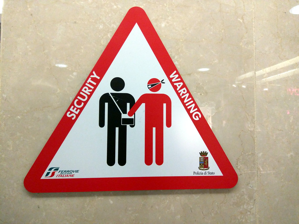
Even when there is no obvious crowding, teams of pick-pockets will create a crowd. In Rome, while riding the metro, we witnessed a young lady attempting to exit the train while a group of tourists from Singapore were trying to board. She kept bumping into those at the front of the group even when they tried to move out of her way. This caused the whole boarding group to bunch up barely getting on the car before the doors closed, which was when she then exited the car. Minutes later, and far from the metro station, a member of this group cried out that his wallet was missing; most likely stolen in the confusion while boarding. So be careful and be aware!
We didn’t begin writing this blog with the intention of making Google Maps the centerpiece, however, we have found no other tool that has been as useful in flattening the learning curve.
We still have more tricks, when using Google Maps, to share with you, to make the whole travel experience less complicated, so watch for our next blog.
All great journeys are unfamiliar when you first set sail. The need to navigate the unfamiliar can often be used as a reason to stay ashore. We think that is a shame when there are so many great tools available to help you find your way.
“You can never cross the ocean until you have the courage to lose sight of the shore”
– Christopher Columbus.
Cheers from these travelers,
Ted and Julia
